Back to the mountains and this time it felt overdue. Since we bailed on the previous weekend due to rain, we decided to stomp out a four peak trip after throwing around some two peak trip ideas that would have been less than acceptably arduous. The weather is getting nice so time to crank the vert back up around 6,000 feet per trip which was our average for last year. We decided on this trip after reading tantalizing tales of the carnage that is the Kate Sleeper Trail and having never done a Sandwich Range hike, this was new terrain and views for us.

Tripyramids + Whiteface + Passaconaway Loop
Gus, Jeff and I rolled up to Hancock campsite and set up, popped some Big 24oz Cans of Moat Iron Mike Pale Ale (fresh, local, amazing) and started a fire. We took a quick walk to the Lincoln Woods suspension bridge before passing out.
Saturday, 5/18/2013
Day One: 8.6 Miles & +4426 Vert/-1797 Vert
We got up a bit late as usual and organized before hitting the Pine Bend Brook trail head at 9:40 am. The trail slowly gets gradually steeper letting you warm up a bit before turning into a pile of rocks and eventually hitting an ice and boulder mix. This trail was a grind and I wasn’t in the shape I usually am due to a slacker week from a strained back.
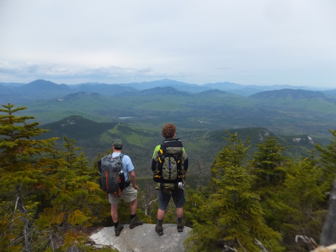
The summit of North Tripyramid was viewless but we destroyed some food and chatted with “Lady Grey” who had just got halfway through her “First grid“. We picked her brain before she ran off and got a good tip on some campsites and a water resupply that really helped out. Thanks! Continuing on we headed to Middle Tripyramid where there were some views of the route ahead.

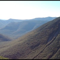
Middle Tripyramid View towards Passaconaway
No views on South so we headed down the South Slide for 100 feet or so before bearing left on the Kate Sleeper Trail.
Sound Tripyramid Slide grade with Waterville Valley
This trail wasn’t too bad until just after the spur trail to East Sleeper. After that it looked like a small tornado rolled through it. I’m not sure how this particular part of the ridge became so damaged and the rest is more or less fine. I would guess between 200-300 blow downs and many were stacked 7-10 trees on top of each other.

Kate Sleeper Trail at East Sleeper Spur Junction, where the damage begins.
Losing the trail is easy here and shins and gear got scraped up. It would have made sense to bring gaiters or pants for this but we weren’t thinking that far ahead. We went straight over these log piles although we did meet a few runners that whacked right around it but we were determined to do the actual trail and witness the conditions. Out of water and 2.5 hours after starting the trail we popped out at the Downes Brook Trail junction and filtered water and rested. Definitely the hardest half mile I’ve ever done but I’m glad we did it, it lived up to its unfortunate reputation for sure.

Gus climbing over blowdowns on Kate Sleeper Trail
After meeting a really awesome Shiba Inu peak bagging pooch, we headed up towards the Blueberry Ledge junction to check it out for campsites. When we got there, a man rolling solo had beat us to a good spot by a small fireplace so we surveyed the area and where impressed by the ledge views.

Whiteface Ledge Views
We picked a small site closer to the ledge to give him privacy and to take advantage of the proximity to the views. I figured with miles of terrain out here, it was pointless to sleep 15 feet away from someone if you didn’t have to, and you never know if they snore.

Tent & Bivy Site
After setting up we cooked dinner on the ledges and watched the sun go down over the Lakes Region. This was an interesting view as I had never seen most of these mountains, namely the Ossipee Range. Unfortunately we missed an epic sunset to the West which I could barely make out through the trees.
We decided to have a fire with CragDwella, the solo hiker and hung out and warmed up a bit before turning in at 9:30.
Sunday, 5/19/2013
Day Two: 8.8 Miles & +1838 Vert/-4642 Vert
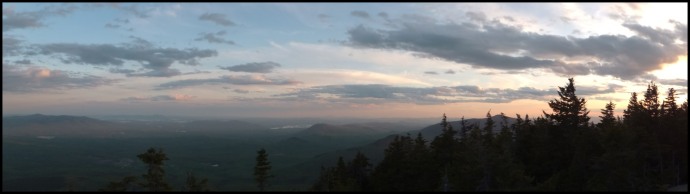
After a nice 10 hour sleep, we woke up to a cloud inversion at 8:00 am after sleeping through the sunrise. I’ve only caught a few of these in my lifetime and only in the winter (while snowboarding) so this was a huge bonus for this trip and made up for the lost sunset.
We lingered here for almost two hours eating breakfast and packing up and soaking in the view before heading off to Whiteface which was closeby. After bagging this viewless peak, we hit a few small viewpoints and a ton of trail ice along the way to Passaconaway and finally found water in a cool shelf fountain just north of the Dicey Mill Trail junction. Further up there’s even more water sources including a nice stream by Camp Rich.
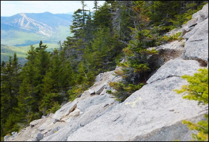
The trail up to Passaconaway was nice and we stopped for lunch on the ledge with a westward view. A few people stopped by and took a photo and continued on. These were some of the better views of the trip in my opinion. After bagging the summit, we headed down the spur trail and got some northern views including the Presidentials.
There was one more ledge where a father and son where eating with some views but they weren’t as good as the view spur trail so we began the descent to the Kanc. This was a fun section and the jokes were flying as we hazed the new kid Jeff a bit. At this point Jeff was obviously hooked on doing the rest of the 48 after getting a good glimpse of them and hearing some of our stories. His very first hike was a full Presi Traverse with his dad so he hit 12 peaks on this trip without even realizing there was a list which is pretty cool.
The rest of the hike gradually went from steep to flat, past hundreds of Painted Trillium and the most elaborate Beaver dam I’ve ever seen on the Oliverian Brook Trail. Hitting the parking lot just after 4:00 pm we actually saw a guy that we had passed just after Whiteface that was doing the same route as us in reverse. He had ran most of it and then ran 3 miles on the road back to his car; over 20 miles and 6k vert. Insane. He gave all three of us a ride back to our car and we headed off to Woodstock for some beers just as it started raining. Jeff crushed a “Death by Sandwich” to his face which is ironic since we hiked the Sandwich range.
Overall an interesting trip with some new views, learned a lot and got a solid night above civilization to recharge.
Total: 17.4 Miles and 6264 feet of Vert with 6440 feet of vert lost
Things I/We Did Right:
– Committed to a harder trip than initially planned despite awful trail condition reports.
– Didn’t push to go farther than the ledges. Great campsite and we caught the best view of the cloud inversion from here.
– Made Jeff carry the fuel. Ha!
– The fire was a nice change of pace since AMC tent sites don’t permit fires.
– Packed pretty light, should have brought some more clothing though.
Things I Did Wrong:
– Needed to bring four liters of water for this. We ran out twice and barely made a resupply.
– Forgot to bring a hat and I probably should have brought pants as it got down to 40 degrees.
– Should have read up on the trails in the AMC guidebook instead of winging it.
– Forgot my tea. Bringing coffee next trip.
– Gus forgot the Whiskey…
TRIP STATS:
Total Peaks Bagged: Four official + two sub peaks.
Total Miles: 17.4
Total Elevation Gain: 6264 feet
Total 4ks: 32/48
Total Backpacked: 29/48
NEW GEAR:
SOG Flash II Knife – Worth every penny. Love this thing.
Bad Ass Awards: Lady Grey, Nathan the Trail runner, CragDwella for soloing, Dude with the Beard that did Tripyramids all the way to Chocorua in one day.

We would like to do this trip in 3 days rather than 2. Can you suggest a second camping area and water sources? We have been to the area many years ago and stayed at an old shelter that is likely no longer there.
Any advice would be appreciated.
Al
Hi Al, Sorry for the multi-year lapse in response! There are some great stealth sites near Oliverian Brook Trail along the brook. Same with Sabbaday and probably Downes. There is an old camp site near the top of the Dicey Mill junction which may be the shelter that is no longer there. I believe you can still camp there and it is near a water source or at least was last two times I was there. Its a longish trip so breaking it into two nights isn’t a bad idea. Cheers!
The rivers off the trails by the Kanc usually have flat enough ground to camp. Besides that you’ll just have to stealth somewhere but there isn’t much on the ridge itself from what I remember. There is an old shelter spot near Passa that I think people still tent at. SOrry this response is 5 years late!
Great info in this, thank you! Do you remember how far you had to walk down the blueberry ledge trail for the area you camped or was it very close to the junction? Planning to do this in 2 weeks. Thank you!
I can’t give up the goods online more than I already have but you shouldn’t have any trouble finding a spot! Just plan water carefully. There is a source at the DOwnes Brook Trail junction and some at the old campsite near the top of Dicey Mill. I think the water crosses the trail there. Enjoy! Its a great trip, I went back after this post and did it again via Sabbaday.